
Oregon 550
- Capture locations and memories with a 3.2 megapixel autofocus digital camera with 4x digital zoom
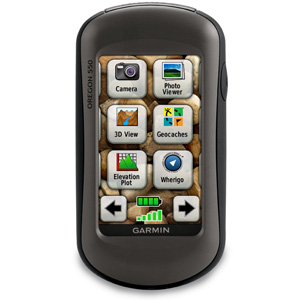
- Tough, 3-inch diagonal, sunlight-readable, color touchscreen display
- Built-in 3-axis tilt-compensated electronic compass shows your heading even when you’re standing still, without holding it level
- Barometric altimeter tracks changes in pressure to pinpoint your precise altitude, and can help you keep an eye on changing weather conditions
- Comes preloaded with a worldwide built-in basemap with shaded relief; add more detailed maps with a MapSource microSD card
- Capture locations and memories with a 3.2 megapixel autofocus digital camera with 4x digital zoom
- Tough, 3-inch diagonal, sunlight-readable, color touchscreen display
- Built-in 3-axis tilt-compensated electronic compass shows your heading even when you’re standing still, without holding it level
- Barometric altimeter tracks changes in pressure to pinpoint your precise altitude, and can help you keep an eye on changing weather conditions
- Comes preloaded with a worldwide built-in basemap with shaded relief; add more detailed maps with a MapSource microSD card
Physical & Performance: Unit dimensions, WxHxD: 2.3″ x 4.5″ x 1.4″ (5.8 x 11.4 x 3.5 cm) Display size, WxH: 1.53″W x 2.55″H (3.8 x 6.3 cm); 3″ diag (7.6 cm) Display resolution, WxH: 240 x 400 pixels Display type: transflective color TFT touchscreen Weight: 6.8 oz (192.7 g) with batteries Battery: 2 AA NiMH batteries (included) Battery life: 16 hours Waterproof: yes (IPX7) Floats: no High-sensitivity receiver: yes Interface: high-speed USB and NMEA 0183 compatible Maps and Memory:
Basemap: yes Preloaded maps: no Ability to add maps: yes Built-in memory: 850 MB Accepts data cards: microSD™ card (not included) Waypoints/favorites/locations: 2000 Routes: 200 Track log: 10,000 points, 200 saved tracks Features and Benefits:
Automatic routing (turn by turn routing on roads): yes (with optional mapping for detailed roads) Electronic compass: yes (tilt-compensated, 3-axis) Touchscreen: yes Barometric altimeter: yes Camera: yes (3.2 megapixel with autofocus; 4x digital zoom) Geocaching-friendly: yes (paperless) Custom maps compatible: yes Photo navigation (navigate to geotagged photos): yes Hunt/fish calendar: yes Sun and moon information: yes Tide tables: Yes (with optional Bluechart) Area calculation: yes Custom POIs (ability to add additional points of interest): yes Unit-to-unit transfer (shares data wirelessly with similar units): yes Picture viewer: yes Garmin Connect™ compatible (online community where you analyze, categorize and share data): yes -
- Download Product Details